

mapping
bring a map but the territory reveals the way

Dear word explorer,
Last week’s cannibal CME did not produce much of an effect, sadly. It’s not a good time of the year for aurora borealis in the Northern Hemisphere, with longer days and the axial tilt of the Earth nodding towards the sun. As I type there’s another CME due to impact the planet’s magnetosphere, but I suspect it will be another poor showing.
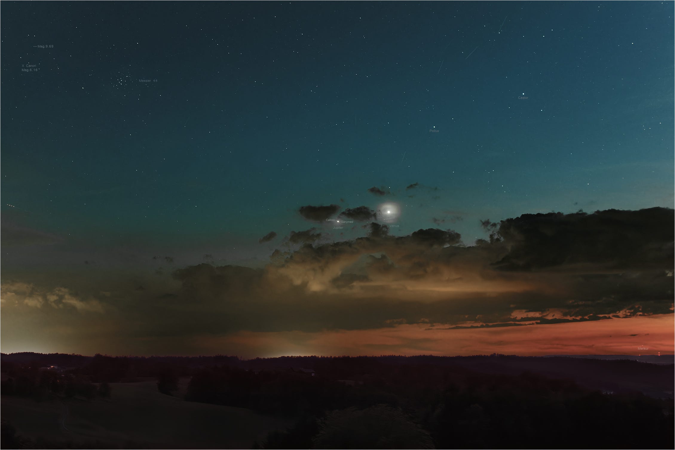
Yet, if you enjoy star gazing then there is a fabulous conjunction visible in the heavens at the moment between Jupiter and Venus, with Mercury dodging about lower in the sky. This feels like a happy June event, considering this is the traditional month for weddings, and these three planets are associated with parties, beauty, and magic.
It’s hard to believe the summer solstice is approaching, especially as we’ve had a mixed bag weather-wise in the West of Ireland. Last week we had tempestuous winds and chilly temperatures, making it feel more like Spring than Summer.
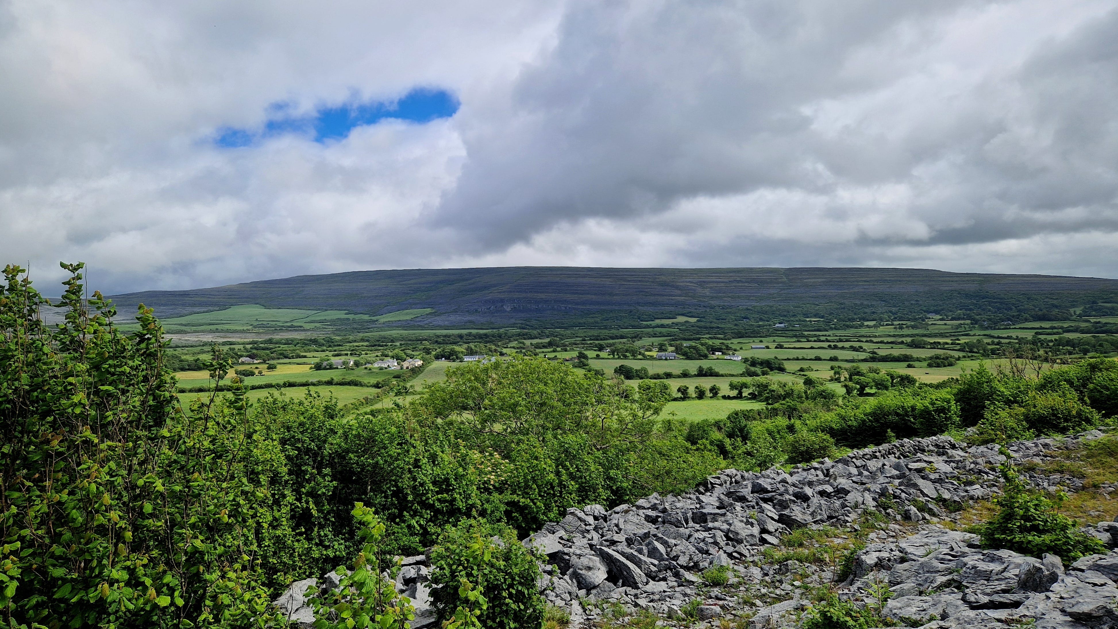
During this time I took a course in the Burren in Co. Clare (a county to the south of me). It possesses a unique, moody landscape on the Wild Atlantic Way, the appropriate description for Ireland’s western coastline. I had a forty-minute drive through roads snaking up and between the lavender mounds of the Burren mountains, often drenched in mist and rain, and sometimes illuminated with roving columns of sunlight.
The Wild Atlantic Way officially begins up north at the Inishowen Peninsula in Co. Donegal and meanders through counties Leitrim, Sligo, Mayo, Galway, Clare, Limerick and Kerry, to finish in Kinsale, County Cork. 3,320 km of Atlantic Ocean separates this edge of Ireland from the coast of Canada and the USA.
Thanks to the West’s squiggly outline, the Wild Atlantic Way route is over 2,600 km long! Not bad for an island that’s only 480 km north-south, and 275 km east-west (the entire coastline of the country is about 7,500 km).
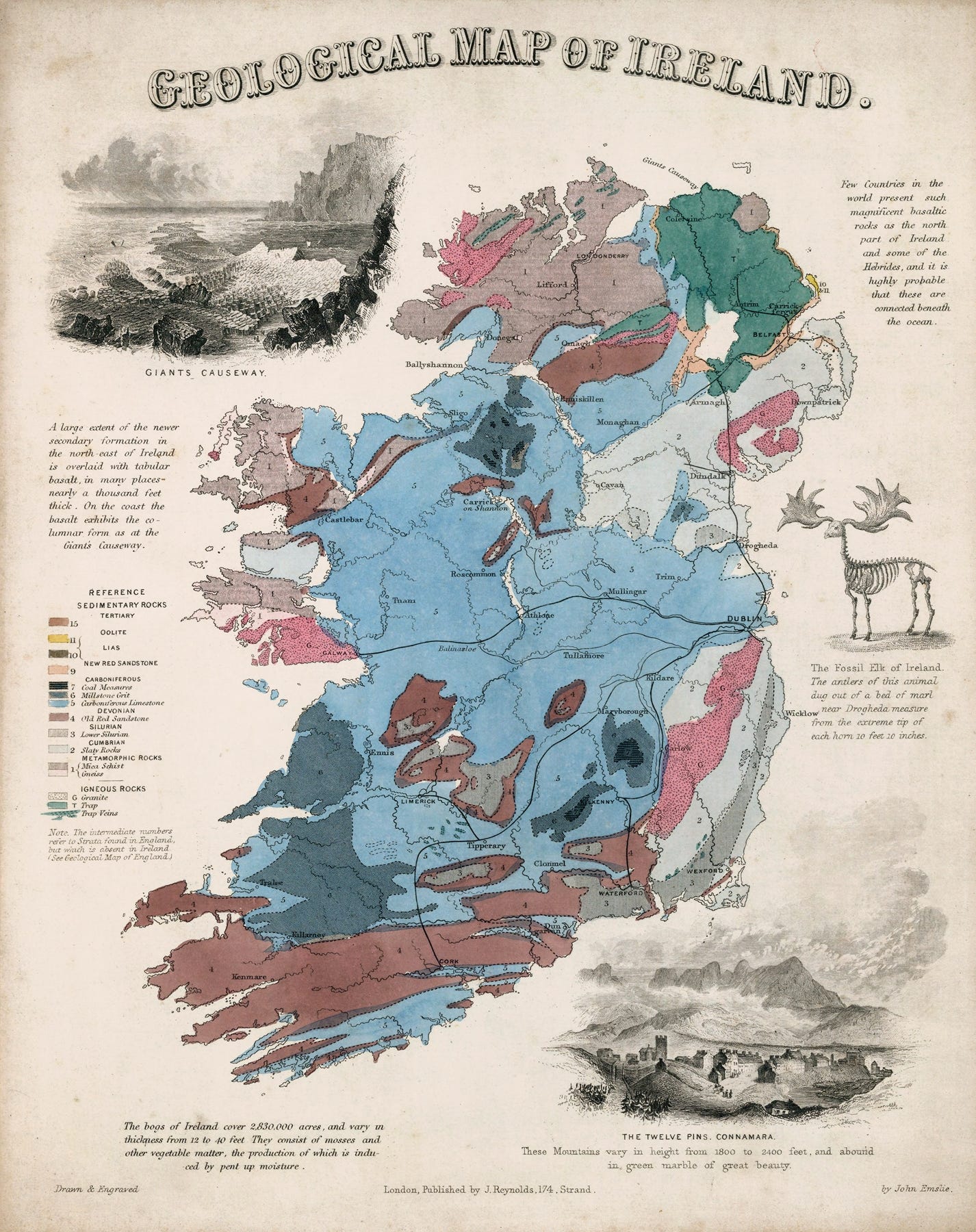
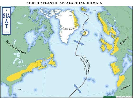
If you are a geology nerd you may know that the edge of Ireland and Scotland used to be part of the Appalachian Mountain system now in North America, before plate tectonics ripped apart our planet’s original supercontinent. The oldest rocks in Ireland are 1.7 billion years old, from the Precambrian era, which are evident in the North West of Ireland. As a result, geological formations in Donegal are the same as in Newfoundland.
So it’s quite curious that there were specific waves of emigration from Ireland to Newfoundland prior to 1815, and primarily from the Southern counties of Waterford, Tipperary and Cork. The subsequent influence on the Newfoundland accent and placenames is striking. Newfoundland and Ireland have a social and a geological connection.
Most people are familiar with the American Appalachian Trail, which is a 3,500 km journey (similar to the width of the Atlantic Ocean) between Springer Mountain in Georgia and Mount Katahdin in Maine. Every year up to three million people attempt to walk sections of this historic route, and anyone attempting a thru-hike1 of the entire trail needs to set aside at least six months. The Appalachian Trail Conservancy (ATC) estimates that around 4,000 people attempt a thru-hike every year but only about 20-25% actually finish it.
Because of the geological resonance between the separated territories of Ireland and Appalachia, a tourist imitative was set up called the International Appalachian Trail (IAT), which encourages long-distance walkers to follow the geographic frequency by flying over the Atlantic and continuing to walk through Donegal and Northern Ireland.
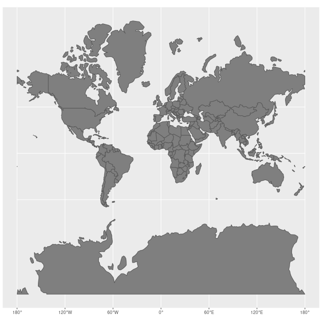
Of course this map is not to scale, as I’m pretty sure that Ireland is not the equivalent length of France!
This reminds me of a famous adage by semantics expert, Alfred Korzybski: ‘The map is not the territory … The only usefulness of a map depends on similarity of structure between the empirical world and the map...’2
This has also been stated as ‘the model is not the data’, or my favourite version, because it is the easiest to digest, by philosopher Alan Watts: “The menu is not the meal.”
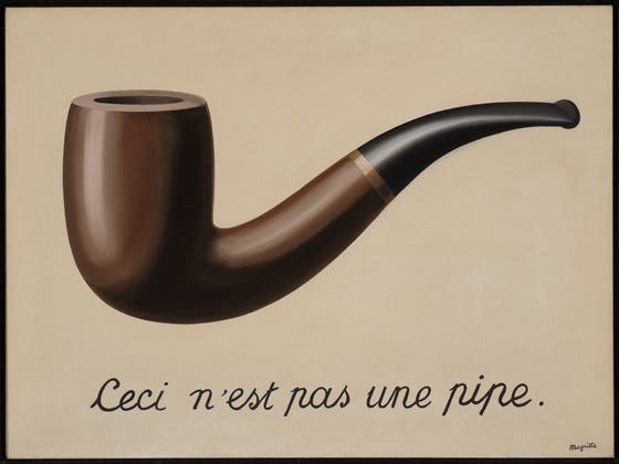
A map is a projection, because we live in a three-dimensional space upon a spinning globe orbiting the sun, and our solar system is moving around the centre of the Milky Way galaxy. Trying to render that spatial existence as a two-dimensional map means that distortions are inevitable. We draw a map, draft a menu, or paint a pipe knowing that these are poor facsimiles of a system in motion yet we attempt it anyway, hoping to approximate the experience, to offer a bridge across disconnection into understanding.
So we come to the difficulty of the on-going use of the 1569 World Map created by Gerardus Mercator, a Flemish geographer and cartographer. To be fair to Mercator, this map was an extraordinary achievement for the time period, and was particularly useful for navigation, the great problem of the ship-faring era.
To traverse the unknown people had to flatten the space and create guidelines. Over time, that shortcut determined the shape of the world.
The Mercator Map has embedded itself in the minds of most of the global population, and we are left with a wonky notion of the physical presence of our land masses.
Yet isn’t that the problem of theory versus experience? It is the difference between studying a location and travelling through its landscape. No picture of a forest adequately expresses the majesty of its living, evolving ecosystem.
Why would anyone go anywhere today? Right now we can fire up our favourite travel app, drop into ‘street view’, and explore a place from the comfort of our sitting room.
This is the age of mapping. It is easy to believe in the grids and lines, the certainty of GPS coverage and AI navigators, forgetting it has only ever been a model, and it can be reframed.
It is extremely useful to be able to chart a course with a reasonable expectation that it will bring us to our destination, but signals drop, road works re-route us, or train strikes mess up our plans.
We can clutch our maps and our schedules and wonder why it is going awry… but it was never guaranteed, we simply imagined a structure and expected the world to conform.
The map is not the territory, and the territory has a say.
Thru-hiking, or through-hiking, is an end-to-end hike of an established long-distance trail, usually accomplished within a twelve-month period. Other examples include Te Araroa in New Zealand, the Camino de Santiago in Spain/France, the Great Divide Trail in Canada, the Great Himalaya Trail in Nepal, and the Kumano Kodo in Japan. Despite our modern conveniences and methods of transportation, people continue to be drawn towards undertaking a walking pilgrimage through ancient routes.
From Science and Sanity, via WikiQuotes.
I have no doubt about the Newfoundland/Ireland connection- you hear someone from Newfoundland with the accent talk and it becomes fairly obvious. Aside from the common surnames...
How funny that you're writing about this. I've long had a dream of attempting the thruhike of the Appalachian Trail, but I would need to do it with some sort of a guide as I'm not terribly good at map reading. Appalachian folklore is something I'm deliberately not getting into, because I just wouldn't have the space for the books, and yet maybe one day...